
Voc Exile Main Menu /Loess Hills
By Ed Perley
Prints of most of these pictures may be purchased. Contact me at the Email address at the bottom of this page.
Announcing a new novel about an adolescent with a very unusual problem.
You have never read a story like this! Check it out
HERE.
Use the Back Button on your browser to return to this page.
The Hills by Douglas Wallis.
A novel about living in the Loess Hills region of western Iowa. You can find it by searching for the author's name on
Amazon.com
The loess hills (pronounced like LUSS) are located in western Iowa and to a lesser extent, in eastern Nebraska. The hills are composed of yellow loess soil overlying older debris left from the last ice age. They are characterized by sharp edged ridge crests, and slopes ranging from gentle to very steep. Cliffs cut into the erosion resistant soil by rivers, streams or roadbuilders a hundred years ago still remain.
Note: A reader recently informed me that loess is a German word that they pronounce something like "lace" with a "puckered a."
During the ice age, the Missouri River (which forms the boundary between Iowa and Nebraska) completely flooded its valley with melt water from the mountains to the west and the great ice sheets to the northeast. In the fall and winter, the flow would subside, exposing miles of broad sand bars. Large quantities of loess, a clay characterized by long interlocking needlelike crystals, were deposited there.
Wind blowing across this expanse, over fifteen miles wide in places, lifted and deposited the loess on both sides of the valley. This process lasted for thousands of years, eventually leaving deposits along the river valley hundreds of feet thick. Heavy loess deposits like this are also found in China. I have also been informed that loess formations like this are also found in Germany and in the Pacific Northwest of the U.S.
When the first settlers arrived, the loess hills were covered with prairie. Because of the frequent grass fires, there were very few trees. After nearly one hundred and fifty years of white settlement, agriculture and the absence of prairie fires have greatly changed the ecology of the area. Trees, mostly the slow growing and drought resistant burr oak, cover most of the slopes too steep for cultivation. Cedar trees are gradually encroaching on drier more exposed areas. The prairie holds on to the steepest, most exposed slopes and hill crests.
The extremely variable nature of the topography of this area has allowed a very diverse variety of vegetation to become established. On the high exposed slopes, plants like yucca, normally found hundreds of miles to the west, thrive. In the deep sheltered hollows, you can find plants that are normally native to Kentucky. And in the deepest ravines, there are mosses and leafy plants that require deep shade and a continuous supply of moisture. The hills east of Mondamin are favored by commercial apple growers because of their gentle slopes and rich soil.
There is an abundance of wildlife in the Loess Hills areas, especially in the areas that are too rugged for cultivation or human habitation. The deer population is quite large, and many areas have been restocked with wild turkeys. The pheasant population is also quite large. Often you can see hawks and vultures soaring above the ridge lines. The variable landscape supports a very good habitat for songbirds.
I have to admit being partial to one particular region of the loess hills in western Iowa, because I grew up in the area. It extends from north of Mondamin, in Harrison County, to west of Onawa, in Monona County. The hills in this area are among the highest and most rugged you will find anywhere along the Missouri Valley. About a dozen of them rise over four hundred feet above the valley (according to U.S. Geological Survey maps). Several especially interesting places are described below.
 Murry hill is a high rugged hill that the highway between
Little Sioux and Pisgah climbs past. You can enjoy views of the
hills and the valley below from two parking areas over two hundred
feet above the valley. If you make the easy climb to the top of
Murray Hill, you will be rewarded with a really spectacular view
in all directions. With a height of 350 feet, Murry Hill is not the
highest hill in the area, but it gives as good a view as you will
find anywhere in the loess hills. Yucca and other short grass priarie
plants cling to the very steep western and southern faces of the hill.
A hill north of the road is covered with a very fine short grass prairie.
To see a larger, more detailed view, click HERE.
Murry hill is a high rugged hill that the highway between
Little Sioux and Pisgah climbs past. You can enjoy views of the
hills and the valley below from two parking areas over two hundred
feet above the valley. If you make the easy climb to the top of
Murray Hill, you will be rewarded with a really spectacular view
in all directions. With a height of 350 feet, Murry Hill is not the
highest hill in the area, but it gives as good a view as you will
find anywhere in the loess hills. Yucca and other short grass priarie
plants cling to the very steep western and southern faces of the hill.
A hill north of the road is covered with a very fine short grass prairie.
To see a larger, more detailed view, click HERE.
The Boy Scouts of America own a very large, rugged area of hill country a couple of miles north of Murry Hill. It comprises over 900 acres, most of it cut by steep forested ravines. Its campgrounds can accomodate thousands of scouts, and there are also more modern facilities for meetings and retreats. There is a very attractive lake, and the area is criss crossed with trails. Admission here is free, though you are required to ask permission before entering. It is most easily reached by taking the road along the edge of the hills north of Little Sioux.
 Preparation Canyon State Park is located to the northeast of the
Little Sioux Scout Ranch. It is most easily reached by the highway
running north of Pisgah, Iowa. The highway to the park travels
through some of the most scenic country you can find anywhere in
western Iowa. The park is on a high forested ridge cut with deep
ravines. There are two excellent picnic areas on top, though there
is no camping.
Preparation Canyon State Park is located to the northeast of the
Little Sioux Scout Ranch. It is most easily reached by the highway
running north of Pisgah, Iowa. The highway to the park travels
through some of the most scenic country you can find anywhere in
western Iowa. The park is on a high forested ridge cut with deep
ravines. There are two excellent picnic areas on top, though there
is no camping.
A network of fine trails makes the whole park accessable. The canyon trail is especially interesting. The deep ravine, covered with a heavy canopy of tall trees and well watered by springs, looks and feels like a rain forest. In the northeast section of the park there is a fine shortgrass prairie. A good place to look for deer in the early morning. There are campsites along the trails in this part of the park.
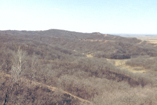
Looking south from Stucker Hill
To the west of the park, a road climbs to a scenic overlook, known locally as Stucker Hill. With a height above the valley of 450 feet above the valley, is the highest hill in the area. An observation platform has recently been built on the summit. From there you can get a very fine view of the rough forested hill country to the south, and of the Missouri River valley to the west.
All of the places described offer excellent opportunities for hiking. But my favorite is the hike from Hubel Hollow, southeast of Little Sioux, to Murry Hill to the north. The hike, about seven miles long, follows the ridge line between the valleys of the Missouri River and the Soldier River to the east. If you take this hike, you should take water. The nearest water faucet will be a long way away. Also stay clear of the cattle. They don't see people very often. And be sure someone knows where you are going, just in case.
PLEASE NOTE: I believe that the entire trail is on public land, except for the Murray Hill area, which has traditionally always been open to hikers. But things can change. If you do plan on doing any hiking anywhere 'off the beaten path,' (including this hike) you should contact the ranger at the Iowa State Forest Headquarters at Pisgah, Iowa. Their hours are 8:00 AM to 4:30 PM Monday through Friday. The telephone number is: (515) 281-8733. And, if you see a 'No Trespassing' sign anywhere, be sure you obey it.
Hubel Hollow, now known as the Gleason-Hubel Wildlife Area, is located just south of the Little Sioux Cemetary, located southeast of the town. You start by following a trail up the ravine. After the trail ends, find a slope to climb on up the ridge. Your goal is a north-south ridge towering above everything else at the east end of Hubel Hollow. If you prefer to follow the high ground, you can climb up the ridge on the north side of the hollow. Just watch out for the steep dropoff covered with brush on the left side of the path. Do not try the south ridge, unless you like climbing over fences and wading through tall weeds.
The ridgeline overlooking Hubel Hollow is a good place to put up a tent, if you like primative camping in the middle of nowhere. The hollow below it to the east contains a grove of large, old trees. Some of the varieties found there are silver maple, red maple, basswood and Kentucky coffee trees.

Except for a road that follows the ridgeline for about a mile, there is no established trail here. There is a path most of the way, thanks to the cattle and deer that make this area their home. Just follow the ridge line to the north. To the west, the Missouri river valley stretches to the horizen. To the east, the hills drop down toward the Soldier River Valley. Beyond the valley, they extend to the eastern horizon. Six of the summits along this route rise over four hundred feet above the valley. The route crosses three "cuts" dug by roadbuilders years ago. One of the cuts was dug for an old stage coach road, long since abandoned. The most challenging parts of the hike are found along two of these cuts. You will have to do some "cliff climbing" up slopes that can be over 45 degrees. Fortunately, the loess soil is soft and there are lots of things to grab hold of. Also, the brush can get pretty thick along these cuts.

By hiking along the ridge line, you will see a very wide variety of terrain. The hills above, and to the north of Hubel Hollow, are high, rounded, and mostly covered with forest. Further north, the hills slope more gently down into broad forested hollows. North of the last cut, the terrain becomes more rugged. The ridge line drops steeply to the forested hollows below. On the last portion of the hike, as the ridge line curves west toward Murray Hill, the south facing slopes become very steep, forming a two hundred foot high wall that is too steep to climb in most places. The opposite slopes, to the north, are more gentle, and the broad flat hollows below are are all farmland or pasture. These hills and those to the north are mostly free of trees. Murray Hill is described in more detail in a previous paragraph.
Waubonsie State Park is located in the southwest corner of Iowa, across the Missouri River from Nebraska City. It is named for Chief Waubonsie of the Pottawattami tribe. The hills here are not as high or extensive as those further north, but the park has one big advantage over the areas described here. It has modern camping facilities and cabins to rent. The western boundaries of the park do not extend to the Missouri River, but from the lookout on the highest hill, you can see four states: Iowa, Nebraska, Missouri and Kansas. The flora of the southern hills is a bit different from those up north. It is the easternmost location in the U.S. where yucca grows naturally. Cacti can also be found here.
The following information is from the Iowa Department of Natural Resources web site. There are 40 Campsites, 24 with electrical hookups, modern shower and rest room facilities and a trailer dump station. Ther is also an equestrian campground. There are seven miles of foot trails and eight miles ofequestrian trails.
Nearbu towns provide additional opportunities. Sidney, Iowa hosts Iowa's largest continuous outdoor rodeo in July. Nebraska City, Nebraska, has a wide range of attractions, including the home of J. Sterling, Morton of Morton's Salt fame, and the founder of Arbor Day. Clarinda was the birthplace of Glen Miller. They hold a special tribute to him there every year. All in all, a very good place to visit for a weekend or longer.
LOCATION: ----Loess Hills Wildlife Area, Onawa, Iowa (South of Sioux City)
DATE: ----------Last weekend in May
CONTACT:
Gloria Kistner
(800)-352-9040 Ext. 6080
gkistner@nwaea.k12.ia.us
WEBSITE:
To Prairie Seminar Website
Spend three days in the loess hills attending lectures on many different subjects. This is a great place to learn about the flora, fauna, nature, geology and history of the area. A primative campground is provided for those wishing to camp there. Some of the lectures and activities are listed below.
Grassland Legacy of the Hills
Birding Walks
The Prairie Fox
Birds and Banding
Prairie Management Techniques
Prehistoric Indians of Iowa
Great Plains/Missouri River History
Wildlife Photography
Reptiles and Amphibians
Geological Origins of the Loess Hills Landscapes
Native American Sign Language
Flora of the Loess HIlls
Grassland Fire Ecology
Places to Visit
Loess Hills State Forest:
Headquarters and Visitor Center in
Pisgah, Iowa.
A good place to learn about the Loess Hills
ph: (515) 281-8733
Link to their site:
Loess Hills State Forest Web Site
Preparation State Park and the Loess Hills Scenic Byway
www.byways.org/image_library/ summary_list.html?CX_COLL=29224
Stone State Park
5001 Talbot Road
Sioux City, IA 51103
ph. 712/255-4698
Stone@dnr.state.ia.us
http://www.state.ia.us/dnr/organiza/ppd/stone.htm
Desoto Bend and Bertrand Steamship Museum:
Desoto National Wildlife Refuge
1434 316th Lane
Missouri Valley, IA 51555
712 642-4121
http://www.omaha.org/oma/bertrand.htm
http://www.omaha.org/oma/desoto.htm
Mount Crescent Ski Area
Crescent, Iowa
(712) 545-3850
http://www.skicrescent.com
Other Attractions along the Loess Hills Scenic Byway
http://www.byways.org/image_library/summary_list.html?CX_COLL=105
For more information about attractions and camp sites, check out the following:
Loess Hills Hospitality Association
P.O. Box 51
Moorehead, IA 51558
(712) 886-5441
loesshil@longlines.com
http://www.loesshillstours.com
Cabins
Loess Hills Hideaway.
Cabins Located between Moorehead and Pisgah.
1004 South 45th St.
Omaha, NE 68106
(402) 551-0690
Bed & Breakfasts
Country Homestead Bed & Breakfast
Larpenteur Memorial Road
Turin, Iowa
(712) 353-6772
Apple Orchard Bed & Breakfast
RR3, Box 129
Missouri Valley, IA
(712) 642-2418
Loess Hills Bed & Breakfast
214 Elm Street
Moorehead, IA 51558
Other Bed & Breakfasts in Western Iowa
http://pionet.net/~inns/loesshills.html
Camping
Lewis and Clark Lake
Onawa, Iowa